
پرونده:World map of countries by ecological footprint (2007).svg

حجم پیشنمایش PNG این SVG file:۸۰۰ × ۳۵۳ پیکسل کیفیتهای دیگر: ۳۲۰ × ۱۴۱ پیکسل | ۶۴۰ × ۲۸۳ پیکسل | ۱٬۰۲۴ × ۴۵۲ پیکسل | ۱٬۲۸۰ × ۵۶۵ پیکسل | ۲٬۵۶۰ × ۱٬۱۳۰ پیکسل | ۹۴۰ × ۴۱۵ پیکسل.
پروندهٔ اصلی (پروندهٔ اسویجی، با ابعاد ۹۴۰ × ۴۱۵ پیکسل، اندازهٔ پرونده: ۱٫۳۶ مگابایت)
این پرونده در ویکیانبار موجود است. محتویات صفحهٔ توصیف آن در زیر نمایش داده میشود. |
خلاصه
| توضیح |
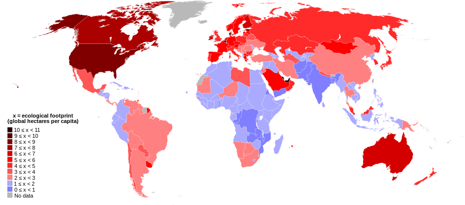
English: World map of countries shaded according to their ecological footprint in 2007 (published on 13 October 2010 by the Global Footprint Network). It is measured by the amount of global hectares that are affected by humans per capita of the country. Lighter shades denote countries with a lower ecological footprint per capita and darker shaded for countries with a higher ecological footprint per capita. The total ecological footprint (global hectares affected by humans) is measured as a total of six factors: cropland footprint, grazing footprint, forest footprint, fishing ground footprint, carbon footprint and built-up land.
Français : Mapemonde colorée selon l'empreinte écologique moyenne des habitants de chaque pays, exprimée en ha par personne, en 2007. Le tons plus chairs correspondent à une empreinte faible, les tons plus sombres à une empreinte plus forte. Six facteurs sont pris en compte pour mesurer cette empreinte: L'agriculture, le pâturage, l'exploitation forestière, la pêche, la production de carbone et l'urbanisation.
No data
0 ≤ x < 1
1 ≤ x < 2
2 ≤ x < 3
3 ≤ x < 4
4 ≤ x < 5
5 ≤ x < 6
6 ≤ x < 1
7 ≤ x < 8
8 ≤ x < 9
9 ≤ x < 10
10 ≤ x < 11 |
| تاریخ | |
| منبع | Self-made with data from list of countries by ecological footprint. |
| پدیدآور | Jolly Janner |
| دیگر نسخهها |
|


.svg?uselang=fa)
اجازهنامه
| من، دارنده حق تکثیر این اثر، این اثر را به مالکیت عمومی منتشر میکنم. این قابل اجرا در تمام نقاط جهان است. در برخی از کشورها ممکن است به صورت قانونی این امکانپذیر نباشد؛ اگر چنین است: من اجازهٔ استفاده از این اثر را برای هر مقصودی، بدون هیچگونه شرایطی میدهم، تا وقتی که این شرایط توسط قانون مستلزم نشده باشد. |
تاریخچهٔ پرونده
روی تاریخ/زمانها کلیک کنید تا نسخهٔ مربوط به آن هنگام را ببینید.
| تاریخ/زمان | بندانگشتی | ابعاد | کاربر | توضیح | |
|---|---|---|---|---|---|
| کنونی | ۳۰ مارس ۲۰۱۸، ساعت ۰۱:۲۴ | | ۹۴۰ در ۴۱۵ (۱٫۳۶ مگابایت) | Sisgeo | Employ a different color for countries under 2.1 gHa, the estimated limit of sustainability. |
| ۲۹ اکتبر ۲۰۱۰، ساعت ۱۸:۴۴ |  | ۹۴۰ در ۴۱۵ (۱٫۶۸ مگابایت) | Jolly Janner | Added a white box to represent the background | |
| ۲۹ اکتبر ۲۰۱۰، ساعت ۱۸:۳۸ |  | ۹۴۰ در ۴۱۵ (۱٫۶۸ مگابایت) | Jolly Janner | white background | |
| ۲۹ اکتبر ۲۰۱۰، ساعت ۱۸:۳۶ |  | ۹۴۰ در ۴۱۵ (۱٫۶۸ مگابایت) | Jolly Janner | white background | |
| ۲۹ اکتبر ۲۰۱۰، ساعت ۱۸:۲۴ |  | ۹۴۰ در ۴۱۵ (۱٫۶۸ مگابایت) | Jolly Janner | == {{int:filedesc}} == {{Information |Description={{en|1=World map of countries shaded according to their ecological footprint in 2007 (published on 13 October 2010 by the Global Footprint Network). It is measured by the amoun |
کاربرد پرونده
صفحهٔ زیر از این تصویر استفاده میکند:
کاربرد سراسری پرونده
ویکیهای دیگر زیر از این پرونده استفاده میکنند:
- کاربرد در ca.wikipedia.org
- کاربرد در el.wikipedia.org
- کاربرد در en.wikipedia.org
- کاربرد در en.wikibooks.org
- کاربرد در eu.wikipedia.org
- کاربرد در fr.wikipedia.org
- کاربرد در gl.wikipedia.org
- کاربرد در hi.wikipedia.org
- کاربرد در it.wikipedia.org
- کاربرد در ms.wikipedia.org
- کاربرد در nl.wikipedia.org
- کاربرد در pl.wikipedia.org
- کاربرد در pl.wikibooks.org
- کاربرد در ro.wikipedia.org
- کاربرد در sk.wikipedia.org
- کاربرد در sr.wikipedia.org
- کاربرد در ta.wikipedia.org
- کاربرد در uk.wikipedia.org
- کاربرد در zh.wikipedia.org
.svg)