
پرونده:South East England districts 2011 map.svg

حجم پیشنمایش PNG این SVG file:۷۴۹ × ۶۰۰ پیکسل کیفیتهای دیگر: ۳۰۰ × ۲۴۰ پیکسل | ۶۰۰ × ۴۸۰ پیکسل | ۹۵۹ × ۷۶۸ پیکسل | ۱٬۲۷۹ × ۱٬۰۲۴ پیکسل | ۲٬۵۵۸ × ۲٬۰۴۸ پیکسل | ۱٬۴۲۵ × ۱٬۱۴۱ پیکسل.
پروندهٔ اصلی (پروندهٔ اسویجی، با ابعاد ۱٬۴۲۵ × ۱٬۱۴۱ پیکسل، اندازهٔ پرونده: ۲٫۱۸ مگابایت)
این پرونده در ویکیانبار موجود است. محتویات صفحهٔ توصیف آن در زیر نمایش داده میشود. |
خلاصه
| توضیح |
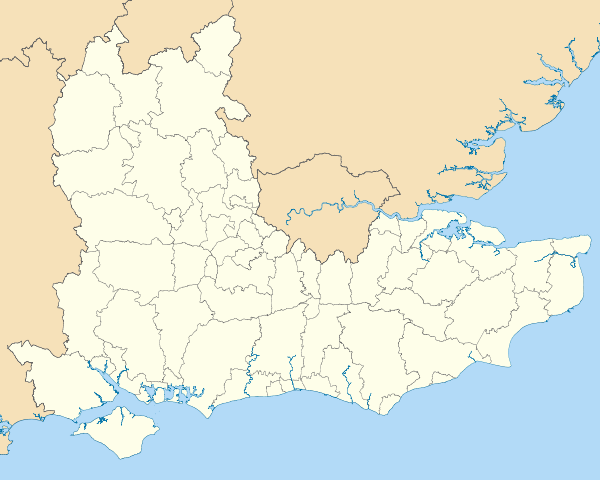
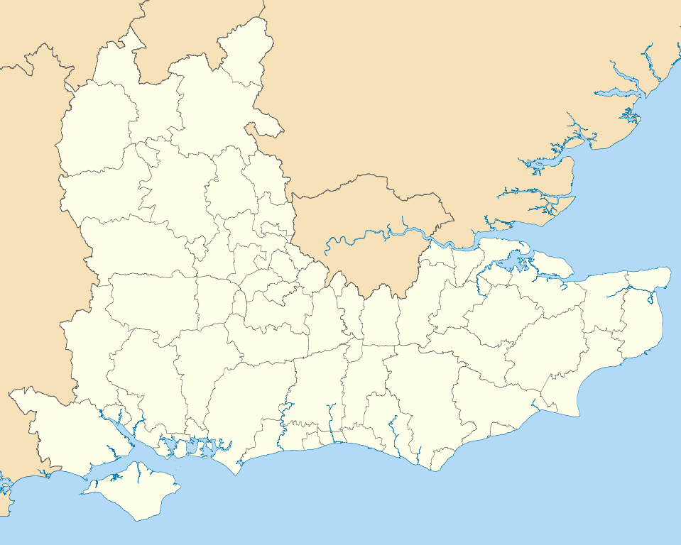
Map of the South East England region showing the administrative districts. Equirectangular map projection on WGS 84 datum, with N/S stretched 160% Geographic limits:
|
| تاریخ | |
| منبع |
|
| پدیدآور | Nilfanion, created using Ordnance Survey data |
| دیگر نسخهها |
آثار انشقاقی از این پرونده: |
اجازهنامه
من، صاحب حقوق قانونی این اثر، به این وسیله این اثر را تحث اجازهنامههای ذیل منتشر میکنم:
این پرونده با اجازهنامهٔ کریتیو کامانز Attribution-Share Alike 3.0 سازگار نشده منتشر شده است.
- شما اجازه دارید:
- برای به اشتراک گذاشتن – برای کپی، توزیع و انتقال اثر
- تلفیق کردن – برای انطباق اثر
- تحت شرایط زیر:
- انتساب – شما باید اعتبار مربوطه را به دست آورید، پیوندی به مجوز ارائه دهید و نشان دهید که آیا تغییرات ایجاد شدهاند یا خیر. شما ممکن است این کار را به هر روش منطقی انجام دهید، اما نه به هر شیوهای که پیشنهاد میکند که مجوزدهنده از شما یا استفادهتان حمایت کند.
- انتشار مشابه – اگر این اثر را تلفیق یا تبدیل میکنید، یا بر پایه آن اثری دیگر خلق میکنید، میبایست مشارکتهای خود را تحت مجوز یکسان یا مشابه با ا اصل آن توزیع کنید.

|
اجازهٔ کپی، پخش و/یا تغییر این سند تحت شرایط مجوز مستندات آزاد گنو، نسخهٔ ۱٫۲ یا هر نسخهٔ بعدتری که توسط بنیاد نرمافزار آزاد منتشر شده؛ بدون بخشهای ناوردا (نامتغیر)، متون روی جلد، و متون پشت جلد، اعطا میشود. یک کپی از مجوز در بخشی تحت عنوان مجوز مستندات آزاد گنو ضمیمه شده است. |
میتوانید مجوز دلخواه خود را برگزینید.
تاریخچهٔ پرونده
روی تاریخ/زمانها کلیک کنید تا نسخهٔ مربوط به آن هنگام را ببینید.
| تاریخ/زمان | بندانگشتی | ابعاد | کاربر | توضیح | |
|---|---|---|---|---|---|
| کنونی | ۱ مهٔ ۲۰۱۱، ساعت ۱۹:۰۴ | | ۱٬۴۲۵ در ۱٬۱۴۱ (۲٫۱۸ مگابایت) | Nilfanion | == Summary == {{Information |Description=Map of the South East England region showing the administrative districts. Equirectangular map projection on WGS 84 datum, with N/S stretched 160% Geographic limits: *West: 2.0W *East: 1. |
کاربرد پرونده
این پرونده در هیچ صفحهای به کار نرفته است.
کاربرد سراسری پرونده
ویکیهای دیگر زیر از این پرونده استفاده میکنند:
- کاربرد در ar.wikipedia.org
- کاربرد در bs.wikipedia.org
- کاربرد در ceb.wikipedia.org
- کاربرد در en.wikipedia.org
- Hastings
- Isle of Wight
- Oxford
- Portsmouth
- Reading, Berkshire
- South East England
- Oxfordshire
- East Sussex
- Brighton and Hove
- Bracknell Forest
- Borough of Runnymede
- Crawley
- Reigate and Banstead
- Mid Sussex District
- Medway
- Hart District
- West Berkshire
- Borough of Waverley
- Royal Borough of Windsor and Maidenhead
- Adur District
- Arun District
- Gosport
- Sevenoaks
- Borough of Dartford
- Basingstoke and Deane
- Worthing
- City of Milton Keynes
- Cherwell (district)
- Wealden District
- Vale of White Horse
- Tonbridge and Malling
- East Hampshire
- Rushmoor
- Test Valley
- Gravesham
- Borough of Swale
- Folkestone and Hythe District
- South Oxfordshire
- West Oxfordshire
- Borough of Spelthorne
- Surrey Heath
- Borough of Elmbridge
- Mole Valley
- Epsom and Ewell
- Tandridge District
- Rother District
- Lewes District
نمایش استفادههای سراسری از این پرونده.