
پرونده:Phet TMO 2010155 lrg.jpg
اندازهٔ این پیشنمایش: ۷۷۱ × ۶۰۰ پیکسل. کیفیتهای دیگر: ۳۰۹ × ۲۴۰ پیکسل | ۶۱۷ × ۴۸۰ پیکسل | ۹۸۸ × ۷۶۸ پیکسل | ۱٬۲۸۰ × ۹۹۶ پیکسل | ۲٬۵۶۰ × ۱٬۹۹۱ پیکسل | ۷٬۲۰۰ × ۵٬۶۰۰ پیکسل.
پروندهٔ اصلی (۷٬۲۰۰ × ۵٬۶۰۰ پیکسل، اندازهٔ پرونده: ۳٫۴۷ مگابایت، نوع MIME پرونده: image/jpeg)
این پرونده در ویکیانبار موجود است. محتویات صفحهٔ توصیف آن در زیر نمایش داده میشود. |
خلاصه
| توضیح |
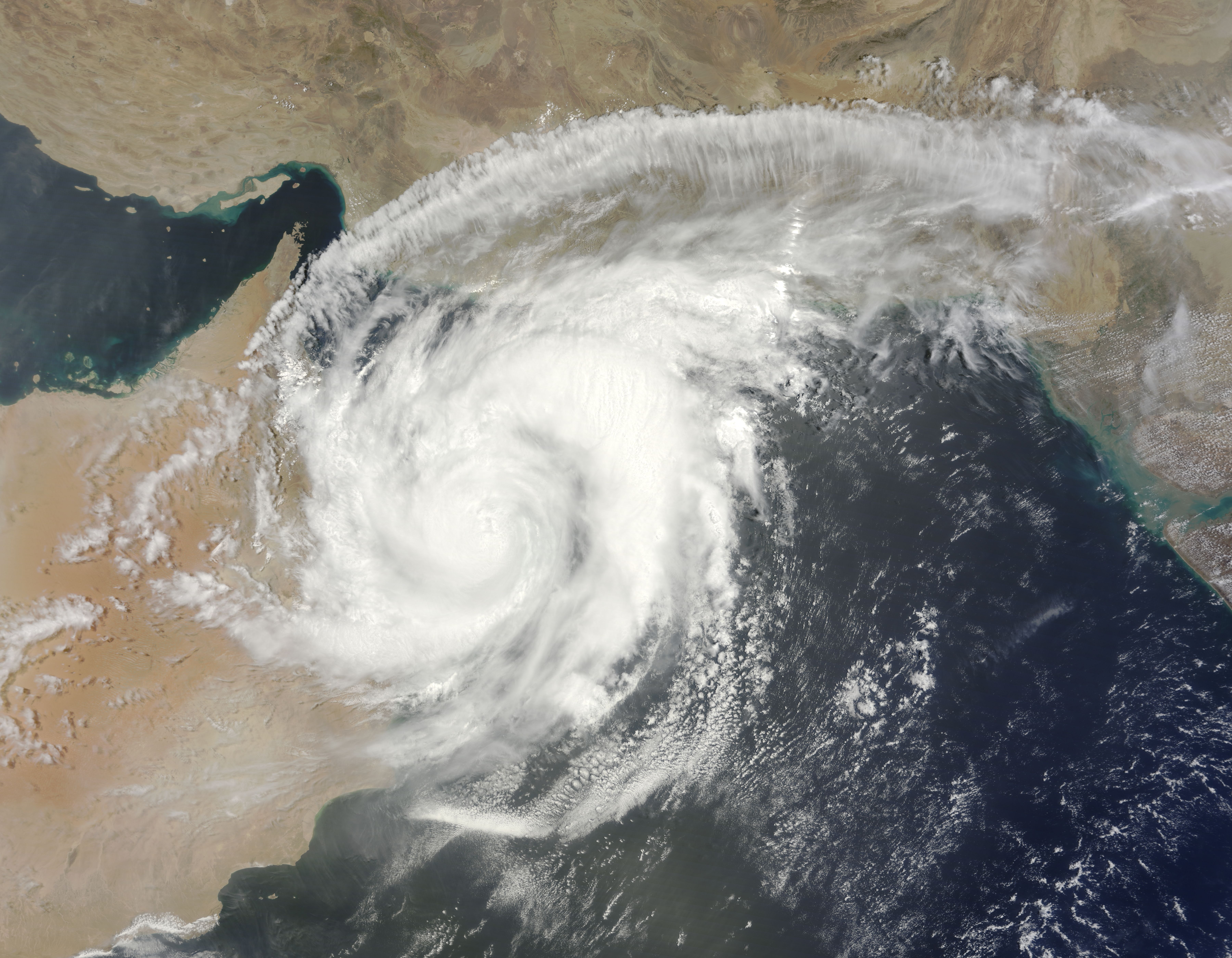
English: Once a powerful Category 4 storm, Cyclone Phet had weakened to a Category 3 storm by the time it came ashore over Oman on June 4, 2010. The Moderate Resolution Imaging Spectroradiometer (MODIS) on NASA’s Terra satellite acquired this photo-like image of the storm at 10:40 a.m. local time on June 4. By that time, Phet had degraded into a Category 1 storm with winds of about 75 knots (140 kilometers per hour or 86 miles per hour).
The storm’s swirling clouds cover most of northern Oman and all of the Gulf of Oman in this image. Though it is partially over land, the storm maintains a distinctive spiraling shape. In its northward trek over the Arabian Sea, Cyclone Phet gave Oman a glancing blow, cutting across the northeast edge of the country. The Joint Typhoon Warning Center forecast that the storm would re-emerge over the Gulf of Oman late on June 4 or early June 5, and move east towards Karachi, Pakistan, as a tropical storm. |
| تاریخ | |
| منبع | http://earthobservatory.nasa.gov/NaturalHazards/view.php?id=44189&src=nha |
| پدیدآور | NASA image courtesy Jeff Schmaltz, MODIS Rapid Response Team at NASA GSFC. Caption by Holli Riebeek. |
| دیگر نسخهها |
|

اجازهنامه
| این پرونده در مالکیت عمومی قرار دارد چرا که توسط ناسا ایجاد شده است. سیاست حق تکثیر ناسا بیان میکند که «مواد ناسا با حق تکثیر محافظت نمیشوند، مگراینکه ذکر شده باشد». (Template:PD-USGov، صفحهٔ سیاست حق تکثیر ناسا یا سیاست جیپیال استفاده از تصاویر را ببینید.) | ||
 |
هشدارها:
|
تاریخچهٔ پرونده
روی تاریخ/زمانها کلیک کنید تا نسخهٔ مربوط به آن هنگام را ببینید.
| تاریخ/زمان | بندانگشتی | ابعاد | کاربر | توضیح | |
|---|---|---|---|---|---|
| کنونی | ۵ ژوئن ۲۰۱۰، ساعت ۰۰:۵۹ | | ۷٬۲۰۰ در ۵٬۶۰۰ (۳٫۴۷ مگابایت) | Captain-tucker | correct image |
| ۵ ژوئن ۲۰۱۰، ساعت ۰۰:۵۴ |  | ۷٬۲۰۰ در ۵٬۶۰۰ (۳۳۷ کیلوبایت) | Captain-tucker | {{Information |Description={{en|Once a powerful Category 4 storm, Cyclone Phet had weakened to a Category 3 storm by the time it came ashore over Oman on June 4, 2010. The Moderate Resolution Imaging Spectroradiometer (MODIS) on NASA’s Terra satellite a |
کاربرد پرونده
صفحهٔ زیر از این تصویر استفاده میکند:
کاربرد سراسری پرونده
ویکیهای دیگر زیر از این پرونده استفاده میکنند:
- کاربرد در bs.wikipedia.org
- کاربرد در en.wikipedia.org
- کاربرد در hr.wikipedia.org
- کاربرد در sh.wikipedia.org