
پرونده:PIA05484 modest.jpg
پروندهٔ اصلی (۱٬۲۷۸ × ۳۵۲ پیکسل، اندازهٔ پرونده: ۴۰ کیلوبایت، نوع MIME پرونده: image/jpeg)
این پرونده در ویکیانبار موجود است. محتویات صفحهٔ توصیف آن در زیر نمایش داده میشود. |
خلاصه
| توضیح |
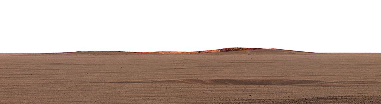
English: This image taken by the Mars Exploration Rover Opportunity's panoramic camera shows the eastern plains that stretch beyond the small crater where the rover landed. In the distance, the rim of a larger crater dubbed "Endurance" can be seen.
This color mosaic was taken on the 32nd martian day, or sol, of the rover's mission and spans 20 degrees of the horizon. It was taken while Opportunity was parked at the north end of the outcrop, in front of the rock region dubbed "El Capitan" and facing east. The features seen at the horizon are the near and far rims of "Endurance," the largest crater within about 6 kilometers (4 miles) of the lander. Using orbital data from the Mars Orbiter Camera on NASA's Mars Global Surveyor spacecraft, scientists estimated the crater to be 160 meters (175 yards) in diameter, and about 720 meters (half a mile) away from the lander. The highest point visible on "Endurance" is the highest point on the far wall of the crater; the sun is illuminating the inside of the far wall. Between the location where the image was taken at "El Capitan" and "Endurance" are the flat, smooth Meridiani plains, which scientists believe are blanketed in the iron-bearing mineral called hematite. The dark horizontal feature near the bottom of the picture is a small, five-meter (16-feet) crater, only 50 meters (164 feet) from Opportunity's present position. When the rover leaves the crater some 2 to 3 weeks from now, "Endurance" is one of several potential destinations. |
| تاریخ | |
| منبع | http://photojournal.jpl.nasa.gov/catalog/PIA05484 |
| پدیدآور | NASA/JPL/Cornell/MSSS |
این نگاره یا ویدیو توسط آزمایشگاه نیروی محرکهٔ جت سازمان ملی هوانوردی و فضایی (NASA)ایالات متحدهٔ آمریکا تحت شناسهٔ عکس: PIA05484کاتالوگ شدهاست. این برچست وضعیت حق تکثیر اثر ضمیمه شده را مشخص نمیکند. یک برچسپ معمولی همچنان مورد نیاز است. Commons:Licensing را برای کسب اطلاعات مشاهده فرمایید. زبانهای دیگر:
|
اجازهنامه
| این پرونده در مالکیت عمومی قرار دارد چرا که توسط ناسا ایجاد شده است. سیاست حق تکثیر ناسا بیان میکند که «مواد ناسا با حق تکثیر محافظت نمیشوند، مگراینکه ذکر شده باشد». (Template:PD-USGov، صفحهٔ سیاست حق تکثیر ناسا یا سیاست جیپیال استفاده از تصاویر را ببینید.) | ||
 |
هشدارها:
|
سیاهه بارگذاری اصلی
- 2004-03-02 23:38 Perl 1100×303× (28911 bytes) This image taken by the Mars Exploration Rover Opportunity's panoramic camera shows the eastern plains that stretch beyond the small crater where the rover landed. In the distance, the rim of a larger crater dubbed "Endurance" can be seen. This color m
تاریخچهٔ پرونده
روی تاریخ/زمانها کلیک کنید تا نسخهٔ مربوط به آن هنگام را ببینید.
| تاریخ/زمان | بندانگشتی | ابعاد | کاربر | توضیح | |
|---|---|---|---|---|---|
| کنونی | ۱۷ فوریهٔ ۲۰۱۳، ساعت ۰۴:۵۳ | ۱٬۲۷۸ در ۳۵۲ (۴۰ کیلوبایت) | Huntster | Full size from original source. | |
| ۲۸ مهٔ ۲۰۰۹، ساعت ۲۲:۵۱ | ۱٬۱۰۰ در ۳۰۳ (۲۸ کیلوبایت) | File Upload Bot (Magnus Manske) | {{BotMoveToCommons|en.wikipedia|year={{subst:CURRENTYEAR}}|month={{subst:CURRENTMONTHNAME}}|day={{subst:CURRENTDAY}}}} {{Information |Description={{en|This image taken by the Mars Exploration Rover Opportunity's panoramic camera shows the eastern plains |
کاربرد پرونده
صفحهٔ زیر از این تصویر استفاده میکند:
کاربرد سراسری پرونده
ویکیهای دیگر زیر از این پرونده استفاده میکنند:
- کاربرد در en.wikipedia.org
- کاربرد در fr.wikipedia.org
- کاربرد در hr.wikipedia.org
- کاربرد در ja.wikipedia.org
- کاربرد در no.wikipedia.org
- کاربرد در ru.wikipedia.org
- کاربرد در sv.wikipedia.org
- کاربرد در uk.wikipedia.org
- کاربرد در zh.wikipedia.org