
پرونده:Omulyakhskaya and Khromskaya Bays, Northern Siberia.jpg

اندازهٔ این پیشنمایش: ۸۰۰ × ۵۳۳ پیکسل. کیفیتهای دیگر: ۳۲۰ × ۲۱۳ پیکسل | ۶۴۰ × ۴۲۷ پیکسل | ۱٬۰۲۴ × ۶۸۳ پیکسل | ۱٬۲۸۰ × ۸۵۳ پیکسل | ۲٬۵۶۰ × ۱٬۷۰۷ پیکسل | ۴٬۶۹۶ × ۳٬۱۳۱ پیکسل.
پروندهٔ اصلی (۴٬۶۹۶ × ۳٬۱۳۱ پیکسل، اندازهٔ پرونده: ۴٫۶۹ مگابایت، نوع MIME پرونده: image/jpeg)
این پرونده در ویکیانبار موجود است. محتویات صفحهٔ توصیف آن در زیر نمایش داده میشود. |
خلاصه
| توضیح |
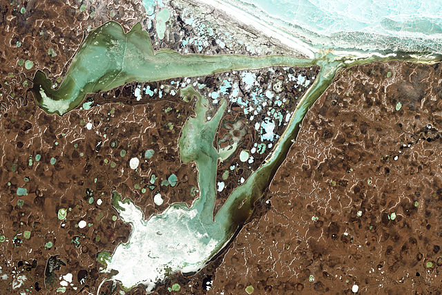
English: Natural-colour image of the Omulyakhskaya and Khromskaya Bays, Russia. The land around the bays is dotted with thermokarst lakes, which result from water released by thawing permafrost. The water in a thermokarst lake doesn’t always stay put; these lakes can melt through the surrounding permafrost and drain into a nearby water body, especially if it sits at a slightly lower elevation. This appears to have occurred in multiple lakes between the bays shown above. (The compound lakes are identifiable by their uneven margins.) Coastal erosion and river migration also can deplete the lakes. Dark brown spots, especially numerous east of Khromskaya Bay, are probably locations of former thermokarst lakes.
Image captured by the Thematic Mapper on the Landsat 5 satellite. Landsat data provided by the United States Geological Survey. Français : Image en couleurs naturelles des baies d’Omulyakhskaya et de Khromskaya (Russie). On distingue autour de ces baies une constellation de lacs thermokarstiques, résultant de l'eau libérée par le dégel du pergélisol. L’eau d’un lac thermokarst peut brutalement disparaitre à travers le pergélisol environnant et se déverser dans un plan d'eau voisin, surtout s'il se trouve à une altitude légèrement inférieure. Cela semble s'être produit dans plusieurs de slacs situés sur cette image (Les lacs composés sont identifiables par leurs marges inégales.) L'érosion côtière et la migration des rivières peuvent aussi vider des lacs. Les taches brun foncé, particulièrement nombreuses à l'est de la baie de Khromskaya, sont probablement des emplacements d'anciens lacs thermokarstiques. Image capturée par le Thematic Mapper sur le satellite Landsat 5. Données Landsat fournies par le United States Geological Survey. |
| تاریخ | |
| منبع | NASA Earth Observatory |
| پدیدآور | Jesse Allen and Robert Simmon |
| دیگر نسخهها |
اجازهنامه
| این پرونده در مالکیت عمومی قرار دارد چرا که توسط ناسا ایجاد شده است. سیاست حق تکثیر ناسا بیان میکند که «مواد ناسا با حق تکثیر محافظت نمیشوند، مگراینکه ذکر شده باشد». (Template:PD-USGov، صفحهٔ سیاست حق تکثیر ناسا یا سیاست جیپیال استفاده از تصاویر را ببینید.) | ||
 |
هشدارها:
|
| برچسبها | این نگاره برچسپگذاری شدهاست: برچسپها را در ویکیانبار مشاهده کنید |
تاریخچهٔ پرونده
روی تاریخ/زمانها کلیک کنید تا نسخهٔ مربوط به آن هنگام را ببینید.
| تاریخ/زمان | بندانگشتی | ابعاد | کاربر | توضیح | |
|---|---|---|---|---|---|
| کنونی | ۱۴ اوت ۲۰۱۱، ساعت ۱۳:۳۹ | | ۴٬۶۹۶ در ۳٬۱۳۱ (۴٫۶۹ مگابایت) | Originalwana | {{Information |Description ={{en|1=Natural-colour image of the Omulyakhskaya and Khromskaya Bays. The land around the bays is dotted with thermokarst lakes, which result from water released by thawing permafrost. The water |
کاربرد پرونده
صفحههای زیر از این تصویر استفاده میکنند:
کاربرد سراسری پرونده
ویکیهای دیگر زیر از این پرونده استفاده میکنند:
- کاربرد در arz.wikipedia.org
- کاربرد در be.wikipedia.org
- کاربرد در bg.wikipedia.org
- کاربرد در ceb.wikipedia.org
- کاربرد در cs.wikipedia.org
- کاربرد در de.wikipedia.org
- کاربرد در en.wikipedia.org
- کاربرد در es.wikipedia.org
- کاربرد در it.wikipedia.org
- کاربرد در pl.wikipedia.org
- کاربرد در tr.wikipedia.org
- کاربرد در uk.wikipedia.org
- کاربرد در www.wikidata.org