
پرونده:John-Tallis-1851-Tibet-Mongolia-and-Manchuria-NE.jpg

اندازهٔ این پیشنمایش: ۸۰۰ × ۵۳۳ پیکسل. کیفیتهای دیگر: ۳۲۰ × ۲۱۳ پیکسل | ۶۴۰ × ۴۲۷ پیکسل | ۱٬۰۲۴ × ۶۸۳ پیکسل | ۱٬۲۸۰ × ۸۵۳ پیکسل | ۲٬۱۰۰ × ۱٬۴۰۰ پیکسل.
پروندهٔ اصلی (۲٬۱۰۰ × ۱٬۴۰۰ پیکسل، اندازهٔ پرونده: ۲٫۳۴ مگابایت، نوع MIME پرونده: image/jpeg)
این پرونده در ویکیانبار موجود است. محتویات صفحهٔ توصیف آن در زیر نمایش داده میشود. |
| توضیح |
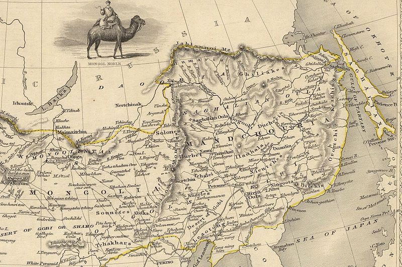
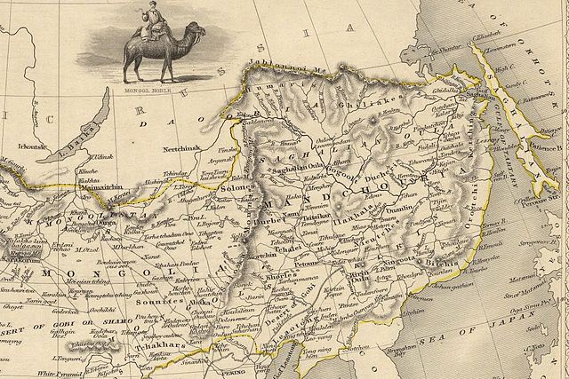
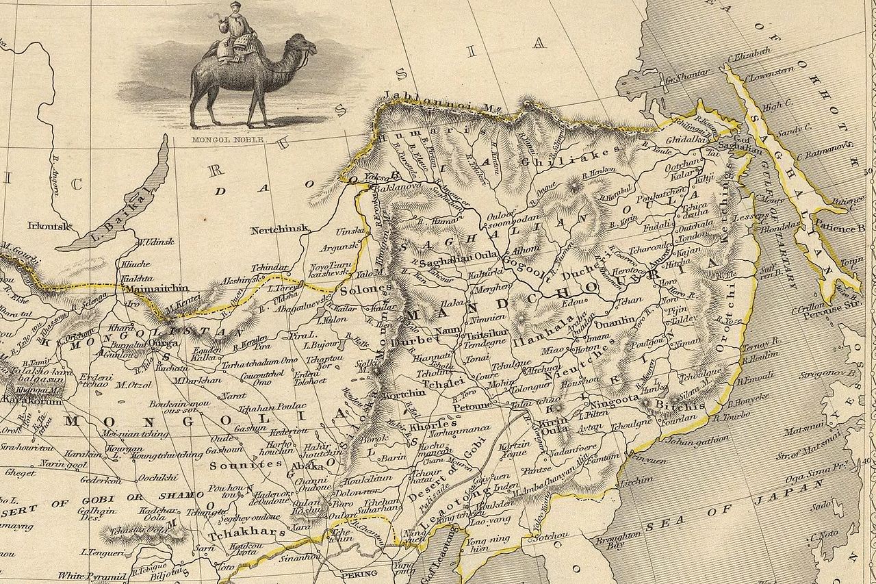
English: The NE section (Manchuria and Mongolia) of the map of the northern and western part of the Chinese Empire - "Thibet, Mongolia, and Mandchouria". The borders are shows as per the 1858 treaty of Aigun. The main Russian center in Transbaikalia is still Nerchinsk, rather than Chita. The outline of Sakhalin is already shown fairly correctly, but the body of water separating it from the mainland is still labeled "Gulf of Tartary" (rather than '"Strait). |
| تاریخ | (UTC) |
| منبع | |
| پدیدآور |
|
| دیگر نسخهها |
 |
| این یک عکس دستکاری شده است به این معنی که به صورت دیجیتالی از نسخهٔ اصلی تغییر یافتهاست. تغییرها: NE section. اصل آن را میتوان در اینجا مشاهده کرد: John-Tallis-1851-Tibet-Mongolia-and-Manchuria-33621.jpg. تغییرها توسط Vmenkov انجام شدهاست.
|
|
این اثر در کشورهایی و مناطقی که مدت زمان حق تکثیر، عمر پدیدآورنده بعلاوهٔ ۷۰ سال یا کمتر بعد از مرگ او است، در مالکیت عمومی قرار دارد. | |
| این پرونده تحت قانون حق تکثیر محدودیت آزاد منتشر شده که شامل تمامی حقوق مربوطه و حقوق نزدیک به آن میشود. | |
سیاهه بارگذاری اصلی
This image is a derivative work of the following images:
- File:John-Tallis-1851-Tibet-Mongolia-and-Manchuria-33621.jpg licensed with PD-old
- 2009-12-07T02:26:08Z Vmenkov 4700x3750 (4267392 Bytes) better resolution, as available from http://www.davidrumsey.com/luna/servlet/detail/RUMSEY~8~1~821~60126:Thibet,-Mongolia,-and-Mandchouria--
- 2009-12-07T01:38:06Z Vmenkov 1289x989 (395245 Bytes) {{Information |Description={{en|1=Map of the northern and western part of the Chinese Empire - "Thibet, Mongolia, and Mandchouria".
Uploaded with derivativeFX
تاریخچهٔ پرونده
روی تاریخ/زمانها کلیک کنید تا نسخهٔ مربوط به آن هنگام را ببینید.
| تاریخ/زمان | بندانگشتی | ابعاد | کاربر | توضیح | |
|---|---|---|---|---|---|
| کنونی | ۷ دسامبر ۲۰۰۹، ساعت ۰۳:۱۰ | | ۲٬۱۰۰ در ۱٬۴۰۰ (۲٫۳۴ مگابایت) | Vmenkov | {{Information |Description={{en|1=The NE section (Manchuria and Mongolia) of the map of the northern and western part of the Chinese Empire - "Thibet, Mongolia, and Mandchouria". The borders are shows as per the 1858 treaty of Aigun. The main Russian cent |
کاربرد پرونده
صفحههای زیر از این تصویر استفاده میکنند:
کاربرد سراسری پرونده
ویکیهای دیگر زیر از این پرونده استفاده میکنند:
- کاربرد در als.wikipedia.org
- کاربرد در ar.wikipedia.org
- کاربرد در bn.wikipedia.org
- کاربرد در ca.wikipedia.org
- کاربرد در cs.wikipedia.org
- کاربرد در cv.wikipedia.org
- کاربرد در da.wikipedia.org
- کاربرد در de.wikipedia.org
- کاربرد در en.wikipedia.org
- کاربرد در en.wiktionary.org
- کاربرد در eo.wikipedia.org
- کاربرد در es.wikipedia.org
- کاربرد در fi.wikipedia.org
- کاربرد در fr.wikipedia.org
- کاربرد در hy.wikipedia.org
- کاربرد در id.wikipedia.org
- کاربرد در it.wikipedia.org
- کاربرد در ja.wikipedia.org
- کاربرد در ka.wikipedia.org
- کاربرد در kk.wikipedia.org
- کاربرد در ko.wikipedia.org
- کاربرد در la.wikipedia.org
- کاربرد در lt.wikipedia.org
- کاربرد در mn.wikipedia.org
نمایش استفادههای سراسری از این پرونده.