
پرونده:1793 Faden Wall Map of India - Geographicus - India-faden-1793.jpg

اندازهٔ این پیشنمایش: ۴۹۷ × ۵۹۹ پیکسل. کیفیتهای دیگر: ۱۹۹ × ۲۴۰ پیکسل | ۳۹۸ × ۴۸۰ پیکسل | ۶۳۷ × ۷۶۸ پیکسل | ۸۵۰ × ۱٬۰۲۴ پیکسل | ۱٬۷۰۰ × ۲٬۰۴۸ پیکسل | ۶٬۰۰۰ × ۷٬۲۲۹ پیکسل.
پروندهٔ اصلی (۶٬۰۰۰ × ۷٬۲۲۹ پیکسل، اندازهٔ پرونده: ۹٫۸۳ مگابایت، نوع MIME پرونده: image/jpeg)
این پرونده در ویکیانبار موجود است. محتویات صفحهٔ توصیف آن در زیر نمایش داده میشود. |
| A Map of the Peninsula of India. | ||||||
|---|---|---|---|---|---|---|
| هنرمند | ||||||
| عنوان |
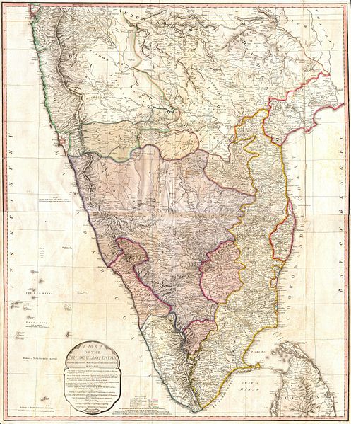
A Map of the Peninsula of India. |
|||||
| توضیح |
English: This map, created immediately after the Third Anglo-Mysore War (1789-92), shows the division of and territorial loss by the Kingdom of Mysore through the 1792 Treaty of Seringapatam.
A "third edition" was created in 1800 showing the territorial changes after the Fourth Anglo-Mysore War (1798–1799). Description from Geographicus: One of the largest and most impressive maps of India to appear in the 18th century. Depicts the subcontinent from Bombay ( Mumbai ) and Aurungabad, south including the northern half of Sri Lanka ( Ceylon ). Printed in 1793 in London by William Faden, “Royal Geographer to the King and to the Prince of Wales”. Includes the routes of various military marches and campaigns including the 1784 March of British Prisoners from Condapoor to Madras, the march of the Marquis of Cornwallis, the march of General Medows, and the march of General Abercromby. Also shows the acquisitions of the British through the Partition Treaty of 1792. The whole is masterfully presented in visually stunning almost three dimensional detail and stunning period color. A must for any serious collection of south Asia maps. Compiled chiefly from papers communicated by the late Sir Archd. Campbell, the surveys of Col. Kelly, Capt. Pringle, Capt. Allan, etc. |
|||||
| تاریخ | ۱۷۹۳ (dated) | |||||
| ابعاد | بلندی: ۳۹٫۰ اینچ (۹۹٫۰ سانتیمتر)؛ عرض: ۳۲٫۰ اینچ (۸۱٫۲ سانتیمتر) | |||||
| آیدی |
Geographicus link: India-faden-1793 |
|||||
| منبع/عکاس |
|
|||||
| اجازهنامه (استفادهٔ مجدد از این پرونده) |
|
|||||
| دیگر نسخهها |
|
|||||

تاریخچهٔ پرونده
روی تاریخ/زمانها کلیک کنید تا نسخهٔ مربوط به آن هنگام را ببینید.
| تاریخ/زمان | بندانگشتی | ابعاد | کاربر | توضیح | |
|---|---|---|---|---|---|
| کنونی | ۲۴ مارس ۲۰۱۱، ساعت ۱۰:۱۶ | | ۶٬۰۰۰ در ۷٬۲۲۹ (۹٫۸۳ مگابایت) | BotMultichillT | {{subst:User:Multichill/Geographicus |link=http://www.geographicus.com/P/AntiqueMap/India-faden-1793 |product_name=1793 Faden Wall Map of India |map_title=A Map of the Peninsula of India. |description=One of the largest and most impressive maps of India t |
کاربرد پرونده
صفحهٔ زیر از این تصویر استفاده میکند:
کاربرد سراسری پرونده
ویکیهای دیگر زیر از این پرونده استفاده میکنند:
- کاربرد در ar.wikipedia.org
- کاربرد در azb.wikipedia.org
- کاربرد در br.wikipedia.org
- کاربرد در ca.wikipedia.org
- کاربرد در de.wikipedia.org
- کاربرد در en.wikipedia.org
- کاربرد در es.wikipedia.org
- کاربرد در fr.wikipedia.org
- کاربرد در it.wikipedia.org
- کاربرد در ja.wikipedia.org
- کاربرد در ml.wikipedia.org
- کاربرد در mr.wikipedia.org
- کاربرد در pa.wikipedia.org
- کاربرد در pnb.wikipedia.org
- کاربرد در ru.wikipedia.org
- کاربرد در ta.wikipedia.org
- کاربرد در te.wikipedia.org
- کاربرد در uk.wikipedia.org
- کاربرد در ur.wikipedia.org