الگو:Location map Canada British Columbia/doc
ظاهر
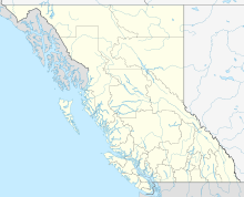
This map template is to be used in conjunction with {{Location map}} to display a dot on a بریتیش کلمبیا map when location is given. This map should only be used for regional districts, municipalities and communities extant since 1966 (when the regional district system was created). It can also be used as part of {{Infobox Settlement}} using the "pushpin_map" parameters. For geographic articles and topics not related to regional district governance, please use {{Location map Canada British Columbia (no subdivisions)}}.
Parameters
[ویرایش]

| Coordinates | |
| Top | 60.3 |
| Bottom | 48.1 |
| Left | -139.3 |
| Right | -113.7 |
Usage
[ویرایش]See {{Location map}} for full syntax (e.g. button size, text, caption)
- Using degree-minute-second
{{Location map|Canada British Columbia|lon_dir=W|lat_dir=N
|lat_deg=|lat_min=|lat_sec=
|lon_deg=|lon_min=|lon_sec=
|caption=Location of {{subst:PAGENAME}} in [[بریتیش کلمبیا]]
|width=220}}
- Using decimal degrees
{{Location map|Canada British Columbia|lat=|long=-|caption=Location of {{subst:PAGENAME}} in [[بریتیش کلمبیا]]}}
See also
[ویرایش]- {{Location map}} for full syntax
- {{Location map Canada British Columbia (no subdivisions)}}
