الگو:جعبه اطلاعات واحد سنگی
| این الگو از لوآ استفاده میکند: |
استفاده
[ویرایش]| {{{نام}}} سن: {{{سن}}} | |
|---|---|
| [[پرونده:{{{نگاره}}}|{{{پهنای نگاره}}}]] {{{زیرنویس}}} | |
| گونه | {{{گونه}}} |
| بخشی از | {{{بخشی از}}} |
| زیربخشها | {{{زیربخشها}}} |
| واحد بالایی | {{{واحد بالایی}}} |
| واحد زیرین | {{{واحد زیرین}}} |
| مساحت | {{{مساحت}}} |
| ضخامت | {{{ضخامت}}} |
| سنگشناسی | |
| سنگ اصلی | {{{سنگ اصلی}}} |
| دیگر سنگها | {{{دیگر سنگها}}} |
| موقعیت | |
| موقعیت | {{{مکان}}} |
| مختصات | {{{مختصات}}} |
| منطقه | {{{منطقه}}} |
| کشور | {{{کشور}}} |
| گستره | {{{گستره}}} |
| مقطع نمونه | |
| دلیل نامگذاری | {{{دلیل نامگذاری}}} |
| نامگذار | {{{نامگذار}}} |
| مختصات | {{{مختصات_اگ}}} |
| دیرینمختصات تقریبی | {{{دیرینمختصات-اگ}}} |
| [[پرونده:{{{نقشه}}}|{{{پهنای نگاره}}}]] {{{زیرنویس نقشه}}} | |
فارسی
[ویرایش]{{جعبه اطلاعات واحد سنگی
|دوره =
|نام =
|سن =
|دوره =
|نگاره =
|پهنای نگاره = <!-- میتوانید از اعداد فارسی نیز استفاده کنید. -->
|زیرنویس =
|گونه = <!-- [[سازند]] -->
|بخشی از =
|زیربخشها =
|واحد بالایی =
|واحد زیرین =
|مساحت = <!-- {{Convert|X|km2|mi2}} -->
|ضخامت = <!-- {{Convert|X|km|mi}} -->
|سنگ اصلی =
|دیگر سنگها =
<!-- مکان -->
|مکان =
|مختصات = <!-- {{coord|xxxx|N/S|xxxx|E/W|region:ZZ_type:TT|display=inline,title}} یا {{coord|dd|mm|ss|N/S|dd|mm|ss|E/W|region:ZZ_type:TT|display=inline,title}} -->
|دیرینمختصات = <!-- {{coord|xxxx|N/S|xxxx|E/W|region:ZZ_type:TT|display=inline,title}} یا {{coord|dd|mm|ss|N/S|dd|mm|ss|E/W|region:ZZ_type:TT|display=inline,title}} -->
|منطقه =
|کشور =
|گستره = <!-- {{Convert|X|km|mi}} -->
<!-- انتخاب گونه -->
|دلیل نامگذاری = <!-- معمولا شهر نزدیک -->
|نامگذار = <!-- میتوانید از اعداد فارسی نیز استفاده کنید. -->
|مکان_اگ =
|سال_اگ =
|مختصات_اگ = <!-- {{coord|xxxx|N/S|xxxx|E/W|region:ZZ_type:TT|display=inline,title}} یا {{coord|dd|mm|ss|N/S|dd|mm|ss|E/W|region:ZZ_type:TT|display=inline,title}} -->
|دیرینمختصات-اگ = <!-- {{coord|xxxx|N/S|xxxx|E/W|region:ZZ_type:TT|display=inline,title}} یا {{coord|dd|mm|ss|N/S|dd|mm|ss|E/W|region:ZZ_type:TT|display=inline,title}} -->
|منطقه_اگ =
|کشور_اگ =
|ضخامت_اگ =
|نقشه =
|زیرنویس نقشه =
}}
انگلیسی
[ویرایش]میتوانید از روی نسخه انگلیسی کپی کنید یا به صورت دستی زیر، وارد کنید:
{{Infobox rockunit
| name           =
| period         =
| age            =
| image          =
| imagesize      =
| caption        =
| type           = [[Geological formation]]
| prilithology   =
| otherlithology =
| unitof         =
| subunits       =
| underlies      =
| overlies       =
| thickness      = up to {{Convert||ft|m|-1}}
| area           =
| map            =
| map_caption    =
<!----Location---->
| location       =
| coordinates    = {{Coord||N||W|display=inline}}
| region         =
| country        =
| extent         = {{Convert||mi|km}}
<!--Type section--->
| namedfor       = <!--Usually a nearby town-->
| namedby        = <!--Author of defining paper-->
| year_ts        = <!--Year of definition-->
| location_ts    = <!--Place,mountain,...-->
| coordinates_ts = {{Coord||N||W|display=inline}}<!--Geographic coordinates-->
| paleocoordinates_ts = {{Coord||N||W|display=inline}}<!--Paleocoordinates-->
| region_ts      = <!--Region of type section-->
| country_ts     = <!--Country of type section-->
| thickness_ts   = <!--Thickness at type section-->
}}
نمونه
[ویرایش]| Marcellus Formation سن: Mid Devonian، ~۳۹۵ تا ۳۹۰ میلیون سال پیش | |
|---|---|
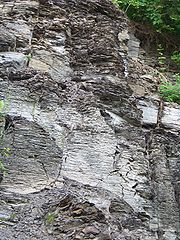
 Marcellus shale exposure above Marcellus، N.Y. | |
| گونه | سازند |
| بخشی از | Hamilton Group |
| زیربخشها | {list of sub-units} |
| واحد بالایی | Mahantango Formation |
| واحد زیرین | Onondaga Formation |
| مساحت | {area} |
| ضخامت | up to ۹۰۰ فوت (۲۷۰ متر) |
| سنگشناسی | |
| سنگ اصلی | شیل (سنگ) |
| دیگر سنگها | سنگ لوح، سنگ آهک، ماسهسنگ |
| موقعیت | |
| مختصات | ۴۲°۵۹′شمالی ۷۶°۲۰′غربی / ۴۲٫۹۹°شمالی ۷۶٫۳۴°غربی |
| منطقه | Appalachian Basin of eastern آمریکای شمالی |
| کشور | {country} |
| گستره | ۶۰۰ مایل (۹۷۰ کیلومتر) |
| مقطع نمونه | |
| دلیل نامگذاری | Marcellus، New York |
| نامگذار | جیمز هال (دیرینه شناس) |
| سال توصیف | 1839 |
| کشور | USA |
{{Infobox rockunit
| name = Marcellus Formation
| age = Mid Devonian، ~{{Geological range|395|390}}
| period = Mid Devonian
| image = MarcellusShaleBank1.jpg
| imagesize = 180px
| type = [[سازند]]
| prilithology = [[شیل (سنگ)]]
| otherlithology = [[سنگ لوح]]، [[سنگ آهک]]، [[ماسهسنگ]]
| region = [[Appalachian Basin]] of<br>eastern [[آمریکای شمالی]]
| country = {country}
| coordinates = {{Coord|42.99|N|76.34|W}}
| caption = Marcellus shale exposure above Marcellus، N.Y.
| unitof = [[Hamilton Group]]
| subunits = {list of sub-units}
| underlies = [[Mahantango Formation]]
| overlies = [[Onondaga Formation]]
| thickness = up to {{Convert|900|ft|m|-1}}
| extent = {{Convert|600|mi|km}}
| area = {area}
| map =
| map_caption = Extent of the Marcellus Formation
| namedfor = [[Marcellus (village)، New York|Marcellus، New York]]
| namedby = [[جیمز هال (دیرینه شناس)]]
| year_ts = 1839
| location_ts = <!--Place،mountain،...-->
| coordinates_ts = <!--{{Coord||N||W|display=inline}}Geographic coordinates-->
| region_ts = <!--Region of type section-->
| country_ts = USA
| thickness_ts = <!--Thickness at type section-->
}}
ریزقالب
[ویرایش]The HTML mark up produced by this template includes an hCard microformat, which makes the place-name and location تجزیهکننده by computers, either acting automatically to catalogue article across Wikipedia, or via a browser tool operated by a person, to (for example) add the subject to an address book. For more information about the use of microformats on Wikipedia, please see the microformat project.
If the place or venue has an "established", "founded", "opened" or similar date, specific to the day, use {{Start date}} (unless the date is before 1583 CE); if it has a URL, use {{URL}}.
hCard از کلاسهای HTML زیر استفاده میکند:
- adr
- category
- country-name
- extended-address
- fn
- label
- locality
- nickname
- note
- org
- street-address
- url
- vcard
خواهشمند است این کلاسها را تغییرنام ندهید یا حذف نکنید. عناصر تودرتویی که از آنها استفاده میکنند را نیز به حالت جمعشده درنیاورید.
