
پرونده:Tanggu Truce Map.jpg

اندازهٔ این پیشنمایش: ۷۹۴ × ۶۰۰ پیکسل. کیفیتهای دیگر: ۳۱۸ × ۲۴۰ پیکسل | ۶۳۵ × ۴۸۰ پیکسل | ۱٬۰۱۶ × ۷۶۸ پیکسل | ۱٬۲۸۰ × ۹۶۷ پیکسل | ۱٬۹۸۵ × ۱٬۵۰۰ پیکسل.
پروندهٔ اصلی (۱٬۹۸۵ × ۱٬۵۰۰ پیکسل، اندازهٔ پرونده: ۴۰۳ کیلوبایت، نوع MIME پرونده: image/jpeg)
این پرونده در ویکیانبار موجود است. محتویات صفحهٔ توصیف آن در زیر نمایش داده میشود. |
خلاصه
| توضیح |
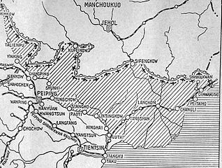
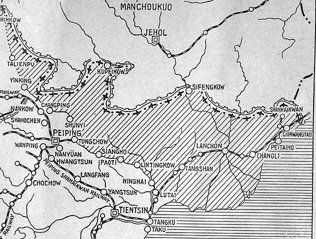
English: The shaded part of this map shows the areas demilitarized by the Tanggu Truce. Note also that the remainder of the Hebei Province, including Beijing and Tianjin, would also be demilitarized of Nationalist forces under the terms of the He-Umezu Agreement, but independent warlords like Song Zheyuan continued to operate there. |
| تاریخ | |
| منبع | a pamphlet called "Sino-Japanese Conflict Elucidated" |
| پدیدآور | Canadian Japanese Association |
اجازهنامه
This Canadian work, of which the author or authors are unknown, is in the public domain in Canada because:
(R.S.C., 2020, c. C-42, s. 6.1, R.S.C., 1993, c. C-42, s. 6.1) |
 | |
|
|
تاریخچهٔ پرونده
روی تاریخ/زمانها کلیک کنید تا نسخهٔ مربوط به آن هنگام را ببینید.
| تاریخ/زمان | بندانگشتی | ابعاد | کاربر | توضیح | |
|---|---|---|---|---|---|
| کنونی | ۱۸ اکتبر ۲۰۱۲، ساعت ۲۲:۴۷ | | ۱٬۹۸۵ در ۱٬۵۰۰ (۴۰۳ کیلوبایت) | CurtisNaito | User created page with UploadWizard |
کاربرد پرونده
صفحهٔ زیر از این تصویر استفاده میکند:
کاربرد سراسری پرونده
ویکیهای دیگر زیر از این پرونده استفاده میکنند:
- کاربرد در ar.wikipedia.org
- کاربرد در en.wikipedia.org
- کاربرد در es.wikipedia.org
- کاربرد در fr.wikipedia.org
- کاربرد در it.wikipedia.org
- کاربرد در ko.wikipedia.org
- کاربرد در lv.wikipedia.org
- کاربرد در nl.wikipedia.org
- کاربرد در pt.wikipedia.org
- کاربرد در ru.wikipedia.org
- کاربرد در uk.wikipedia.org